Day 1
A volcano cross-section including:
- Roque del Conde and the southern cone field
- the Ucanca Caldera wall west of Boca Tauce
|
| |
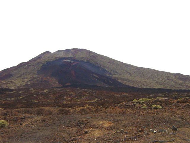 |
Pico Viejo and the site of the Chahorra ("Teide's nostrils") eruption of 1798. Viewed from the roadside mirador. Lavas from this eruption spread nearly as far as the Ucanca Caldera rim. |
| |
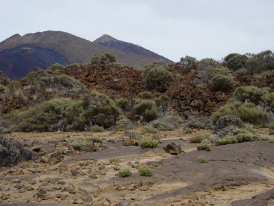 |
Pico Viejo, 1798. The rubbly flow front of the a'a lava flow is in the middle distance. Pico Viejo, and the eruption site are in the background at left, with the sharp peak of Teide behind. |
| |
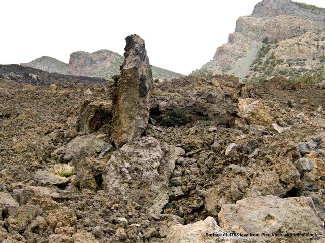 |
Pico Viejo, 1798. This shows the top of the lava flow, near the caldera rim in the background. A'a lava is produced from more viscous magmas than pahoehoe. At the flow front, the rubbly material, similar to that shown here, falls forward and is overridden. Therefore, a'a lava flows tend to have a rubbly base and top, but the initially hotter interior is more massive and may develop cooling joints. |
| |
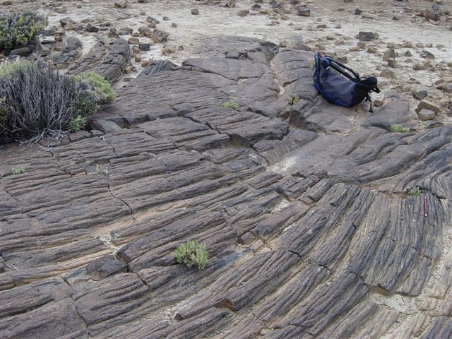 |
Canada de Pedro Mendez. Ropy pahoehoe lava at the west end of the Ucanca Caldera, near the caldera rim, and close to the 1798 a'a lava flow front. This pahoehoe lava is highly vesicular and its matrix is glassy. It is produced by "runny", low viscosity magmas. |
Day 2
The north-east, including:
- the Guimar Valley landslip
- the Dorsal Ridge and return through the calderas.
|
| |
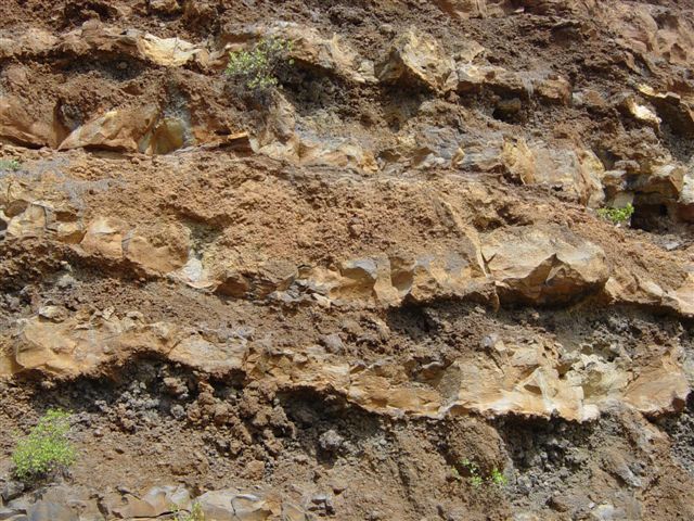 |
Guimar valley. Very thin basalt lava flows at a roadside exposure. Rubbly layers lie above and below each flow. |
| |
 |
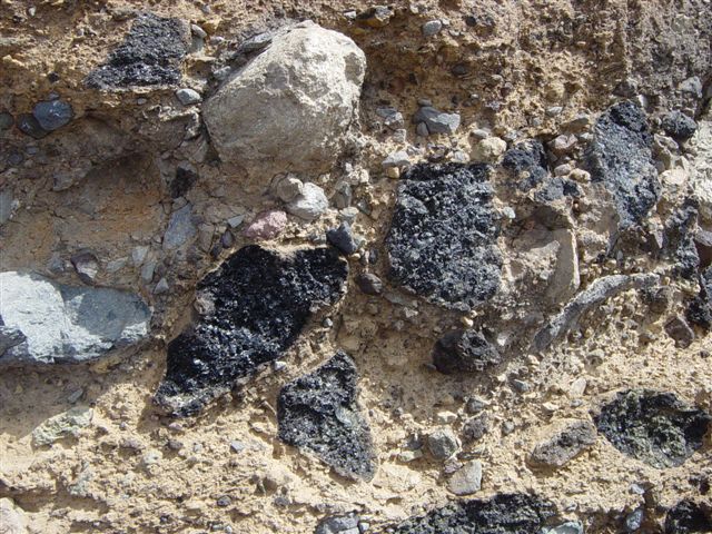
The Montana Negrita "paintbox curves". White layers are of light, porous, pumice fragments, from a distant plinian source. Black layers are of basalt from a nearby strombolian source. Reddish layers are of basalt which has been oxidised by ground water soon after deposition. |
| |
 |
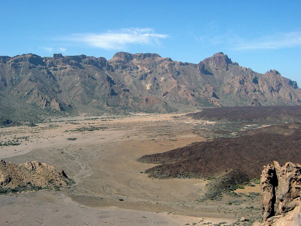
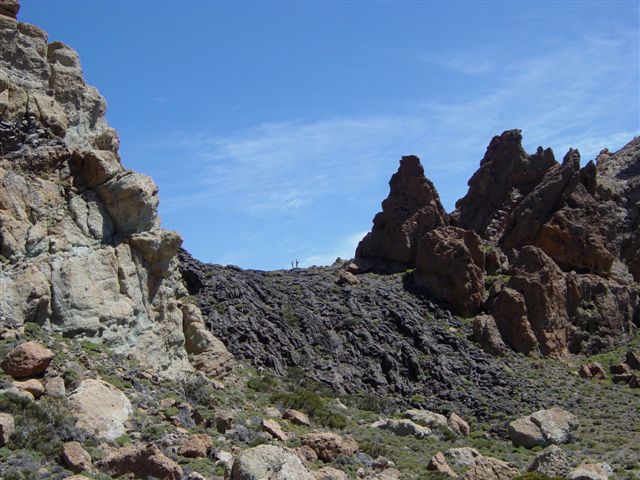
General view of the east end of the Ucanca Caldera with the Roques de Garcia at right. The Ucanca Caldera is one of three which make up the Las Canadas Calderas. El Catedral is the sharp pinnacle behind the light-coloured depositional feature in front. An ancient Pico Viejo a'a lava flow covers distant part of the caldera floor at left, with nearer parts floored by pumice gravel. |
Day 3
The Bandas del Sur:
|
| |
 |
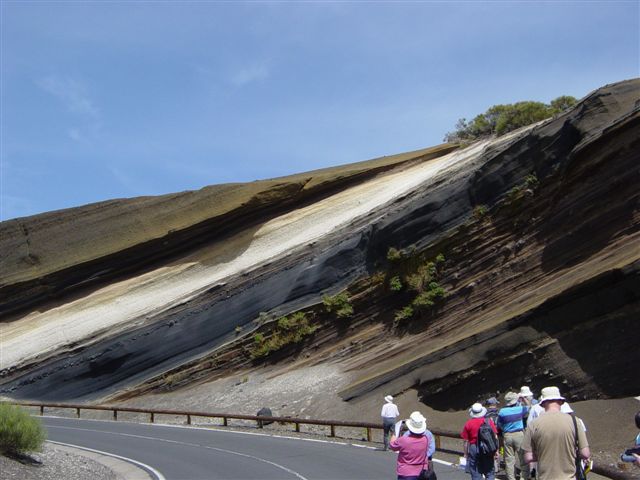
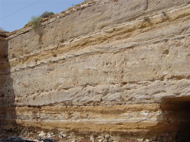
La Cantera schoolhouse quarry, in the Bandas del Sur, illustrates distal pyroclastic deposits. Lower unit is Granadilla Pumice, a plinian airfall deposit of lightweight, angular lapilli and tiny lithic fragments. Upper brownish unit is unwelded Granadilla ignimbrite, with indistinct layering and trails of lithic lapilli. A thin base surge deposit lies between these main units. |
| |
 |
Barranco del Azucar, Arico Ignimbrite Member, Bandas del Sur. This was deposited by a phonolytic pyroclastic flow and is distinctive as the only welded ignimbrite in the area. It contains a variety of clasts, with obsidian and white and black pumice, with tiny blue nosean crystals. |
| |
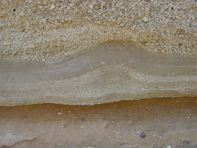 |
The "wavy deposit", Arico-Poris road, Bandas del Sur. The lower unit is upper part of a 1m ignimbrite with frequent clasts belonging to the Poris Member. This is followed upward by the wavy deposit, lying at the base of the La Caleta Member - the waviness is of controversial origin. Typical plinian lapilli on top. |
| |
 |
Poris Member near autopista tunnel. These units are accretionary lapilli tuffs and ash layers. Tubed pumice clasts are evidence of vapour phase alteration. |
| |
 |
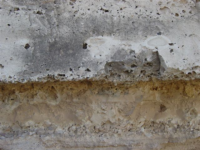
Arico-Poris road quarry. Dark brown palaeosols and a coarse phonolite lava at base are readily identified. Full succession is difficult to work out, but is, from top, Abrigo ignimbrite, reverse graded plinian fall (2m), the wavy deposit, upper grey lithic ignimbrite, palaeosol, plinian fall (2m), discontinuous cross-stratified ash cloud surge, lower grey lithic ignimbrite, palaeosol, and phonolite lava. |
Day 4
The Old Basaltic Series and recent eruptions:
- Masca
- Punta de Teno
- El Palmar
|
| |
 |
Masca car park. This series of lava flows, recently exposed by roadworks, shows a fine alternation of non-porphyritic layers and layers rich in black pyroxene and red weathered olivine phenocrysts. The horizontal surface is a lava flow top, remarkable for showing small scale pahoehoe! |
| |
 |
The El Palmar scoria cone. This is mostly built of black scoria, dipping radially outwards, with syn-depositional faulting also angled outwards. The scoria derived from frothy basaltic magma. Upper parts are reddish, due to ferrous alteration. |
| |
 |
Punta de Teno. This headland in the north-west of the island is mostly of relatively soft black scoria, with huge volcanic bombs, which can be assumed to lie on a base of resistant lava flows. There are fine views towards the cliffs of Los Gigantes (as illustrated in the reports for my November 2007 visit). |
| |
 |
Garachico. Most of the former town and all of its harbour were destroyed in the Montana Negra eruption of 1706. The lava flowed down the valley in the foreground, and built out the lava delta on which the modern town is built.
(nicely seen in Google Earth) |
Day 5
- Las Canadas Calderas
- hydrothermal alteration at Los Azulejos
- lava tubes
|
| |
 |
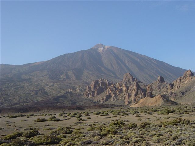
The Ucanca Caldera as seen from Roques de Garcia. The arcuate shapes behind the flow fronts of the dark a'a from Pico Viejo eruptions can be detected. |
| |
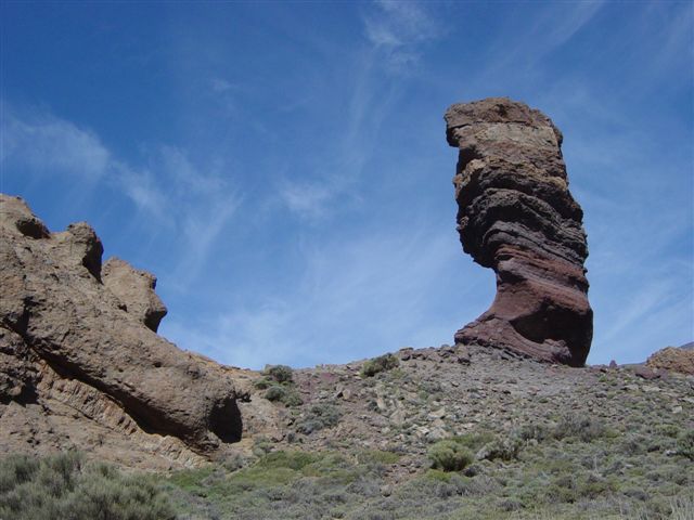 |
The famous "Big Pillar", or Cinchado, at the Roques de Garcia. It is built mostly of breccias from the Lower Group, dating from about 2-3 Ma, dipping inwards towards the centre of the Ucanca Caldera, (hidden in this view at left). |
| |
|
Ropy pahoehoe, east of Roques de Garcia, which has built up as mounds, or tumuli. An a'a lava flow is seen further back. The pahoehoe in this location shows frequent large, shiny (2cm) plagioclase crystals on the top surfaces, which show up as the more familiar thin laths on end sections. |
| |
 |
A lavafall near the top (north) end of the Roques de Garcia. This formed in the same manner as a waterfall, but of course, the lava solidified! |
| |
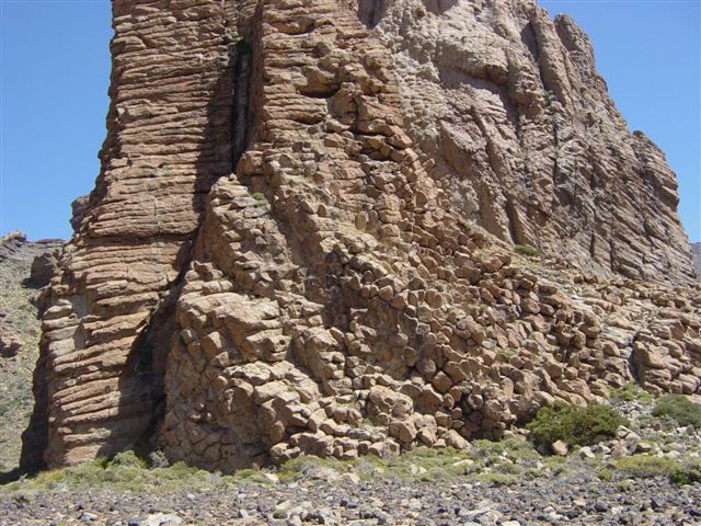 |
El Catedral. This phonolite volcanic neck forms a prominent feature on the floor of the Ucanca Caldera, on the west side of the Roques de Garcia. All the cooling joints can be observed to be radiating inwards towards the centre of the feature. |
| |
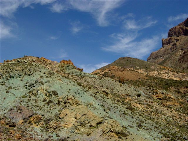 |
Los Azulejos. Hydrothermal alteration of Canadas Lower Group rocks has produced vividly coloured products with white minerals (illite and kaolinite) and blue-green minerals (chlorite and epidote), as displayed here. |
| |
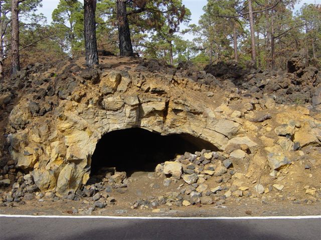 |
Lava tubes. [alongside the road from Boca de Tauce which crosses the 1798 lava field; close to the 18km post] These have been revealed as a result of excavation for the road construction. As magma flows down a channel, solidification takes place first at the cool margins and top of the flow, so that a tube may develop. When magmatic activity wains, the magma drains out, at least partially, leaving an empty tube, sometimes traceable for considerable distances. |
| |
Day 6
Our mystery feature turned out to be Montana Pelada, a tuff ring on the south Tenerife coast. This was created by an explosive phreatomagmatic eruption, under very shallow water. Outer tuff layers of the ring were found to dip outwards, with dips lessening on the inner margins of the ring. Tuff layers were variable in texture, many with a high density of brecciated basalt fragments about 1cm across, but with some larger bombs.
At a much later date, the tuff ring was enveloped in a plinian airfall deposit from a distant source - this is brownish and contains palaeosols, and accumulated in the depressed centre of the ring. This was then followed upwards by a predominantly whitish layer (Poris deposit) with frequent volcanic bombs.
Recent erosion has stripped away the white and brown layers from the tuff margins, and has variably eroded the centre of the ring, such that slightly higher parts are topped with the white layer, while the brown layer has become exposed in lower ground.
(Montana Pelada shows up beautifully in Google Earth. It lies directly under the flight path east from Tenerife Sur airport, and is easily found simply by tracing a line east from the runway to the coast. The tuff ring is very obvious, and it is even possible to detect the white and brown layers, as described, without difficulty).
|