| 6th - 13th September 2008 | |||||||||||||||||||||||||||||||||||||||||||||||||||||||||||||||
NORTH ANTRIM COAST |
|||||||||||||||||||||||||||||||||||||||||||||||||||||||||||||||
Tour: Geowalks (8th - 13th September) |
|||||||||||||||||||||||||||||||||||||||||||||||||||||||||||||||
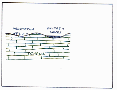
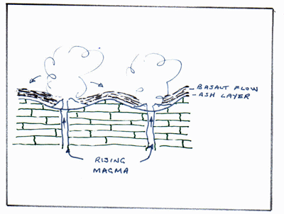
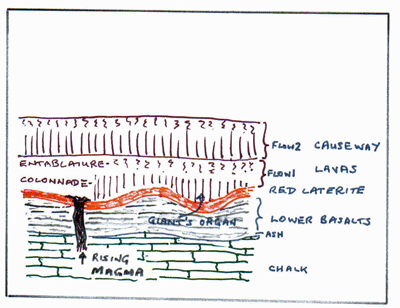
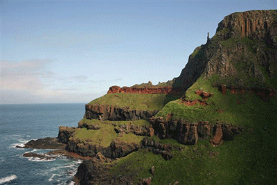
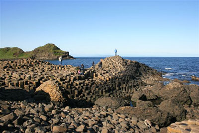
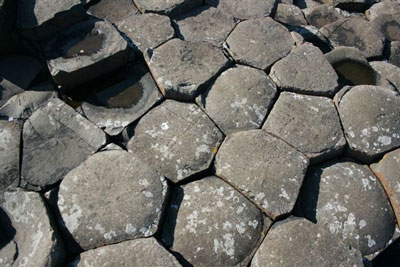
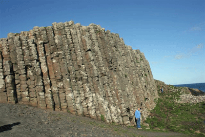
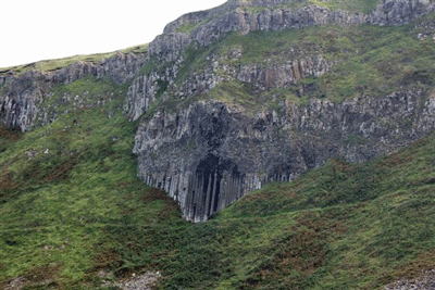
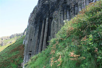
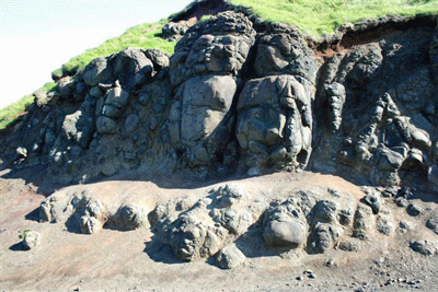
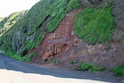
Summary of Geology : The oldest rocks exposed in the North Antrim area are the Dalradian rocks, found to the east of Ballycastle, around Murlough Bay. These started to form about 600 Ma as sandstones, mudstones and limestones in the Iapetus Ocean of the Southern Hemisphere. Closure of this ocean at about 420 Ma resulted in the sediments becoming intensely folded and metamorphosed to form rocks such as schists and phyllites. The next oldest rocks significantly represented are Carboniferous sedimentary rocks, formed as the now united basement crossed the Equator at about 350 Ma, in a hot, humid environment of shallow seas and densely vegetated flood plains and deltas. The resulting sandstones, limestones, shales and thin coals are exposed today in only a small coastal area east of Ballycastle. As Ireland drifted further north into latitudes similar to the present day Sahara in Triassic times, around 250 Ma, red sandstones and mudstones were laid down, but are found today in only a limited area around Murlough Bay. Jurassic times are represented only by limited exposures of Lower Jurassic (Lias) around White Rock Bay, and in the vicinity of the Portrush Sill, where they were later to be baked by heat from the Tertiary intrusion. The soft Triassic and Jurassic rocks of the Antrim coast are prone to landslips, and continue to cause problems even today. Despite these representations of older rock formations, the geology of the North Antrim coast is strongly dominated by those of the succeeding Cretaceous and Tertiary periods. Sea levels rose significantly in Cretaceous times, 150 - 80 Ma, to cover most of Britain with warm, shallow seas. The remains of micro-organisms called coccoliths accumulated on the ocean bottom to build layers of chalk. Larger life forms are represented as fossils - belemnites were squid like creatures, and flint nodules are thought to have formed from the siliceous material in sponges. By about 65 Ma sea levels had fallen and the chalk land surface had eroded into gently undulating hills and valleys. Early in Tertiary times, intense tensional forces due to the splitting open of the North Atlantic Ocean initiated extensive volcanicity in the North Antrim area. Outpourings of black basaltic lava spread over the area to form the Lower Basalts. This was followed by a period of dormancy, perhaps lasting for 100,000 years, during which the surface of the Lower Basalts was eroded down to form hills and valleys and chemical weathering produced the red laterite of the Lower Interbasaltic Formation. Volcanicity resumed in the form of the Causeway lavas, a lighter coloured, silica-rich lava known as a tholeiite, which formed thick flows, especially where it ponded into valleys in the Lower basalt surface, as at the Giant's Causeway, where the first flow reaches 100 metres in thickness. River water flowing over each lava flow surface helped form the familiar collonade and entablature columnar jointing, perpendicular to cooling surfaces. A further period of dormancy was to follow eruption of the Causeway Lavas, resulting in the Upper Interbasaltic Formation, only to be followed by another period of volcanicity which produced the Upper Basalts. Volcanicity finally died down by about 58 Ma. Evidence of Tertiary volcanicity in North Antrim is not limited to lava flows and associated rocks. Volcanic vents are found such as the one at Carrickarede, and there are numerous dykes and sills, with examples of the latter at Fair Head and at Portrush. Late Tertiary denudation, culminating in the Quaternary glaciation shaped the landscape as we know it today. The lava flow cover has protected the underlying chalk from the erosion which has stripped it away from most of north-west Britain, such that a semi-continuous strip of chalk is now exposed on the coastal margins of much of the Antrim Lavas. Following the glacial period, global sea level rise due to melting ice was balanced by the fall due to isostatic rebound of land level, thereby creating the familiar raised beaches and sea stacks of the coastal area.
Programme : 9th September: Ballycastle towards Fair Head. The intended destination for the day was Murlough Bay, to study the Dalradians and Triassic sandstones exposed there. Unfortunately, very heavy rain prevented us from reaching these outcrops from our base at Ballycastle, although eroded pebbles of Dalradian schist were found along the shoreline. We were able to study much younger Carboniferous sedimentary rocks along the shore closer to Ballycastle. These include sandstones, mudstones and shales, passing upwards into thin coals, which were once worked extensively around the Colliery Bay area.
10th September: Rathlin Island. Despite very heavy rain at times, we had a good day on Rathlin Island. The lower part of the island is dominated by well exposed Cretaceous chalk, while Tertiary basalt lavas dominate the higher ground. We found good exposures of these lavas near the East Lighthouse, and further towards the west, although many areas of the island are covered in extensive, poorly-drained glacial clays. The beach near the harbour is remarkable for its strongly contrasting black and white cobbles - of local chalk and basalt.
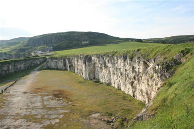
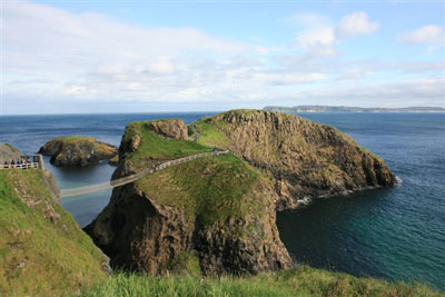
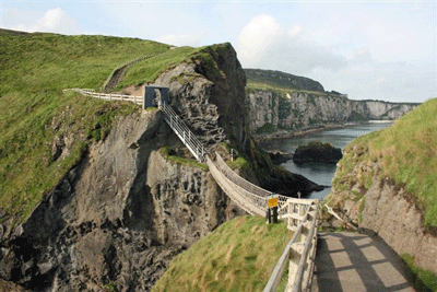
11th September: Carrickarede to White Park Bay Today stayed dry until we had all but completed the itinerary for the day - but we got soaked waiting for the bus back to Ballycastle! One of the vents from which the Tertiary lavas were extruded is exposed at the popular tourist site of Carrickarede. The agglomerate of the vent has eroded deeply, partly as a result of the high content of soft chalk incorporated in the vent material. The island is capped by a harder dolerite sill. Close by, we saw chalk with flints at the huge quarry at Larrybane. Further west, we were able to examine the faulted contact between the chalk and the basalt lavas west of Ballintoy, while at White Park Bay, the more adventurous members of the group walked inland to find the contact between the chalk and soft shales of the preceeding Jurassic Period (Lias).
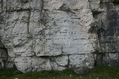
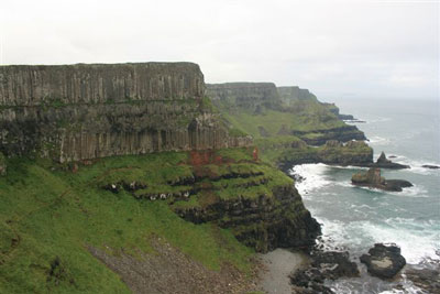
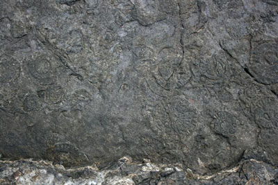
12th September: Giant's Causeway and Portrush This was a generally dry, and often sunny day. We started near Dunseverick Castle, and walked westwards along the cliff top path, which offers fine views of the Causeway basalts, before reaching the Causeway itself. After spending some time examining the columnar basalts and red laterite interbasaltic layers, we transferred by taxi to Portrush to have a look at the sill, which intruded in Tertiary times into mudstones of the Liassic. Close proximity to the sill hardened the mudstones, helping to preserve abundant ammonite fossils.
|
|||||||||||||||||||||||||||||||||||||||||||||||||||||||||||||||
|
|||||||||||||||||||||||||||||||||||||||||||||||||||||||||||||||