20th - 24th August 2007 |
|||||||||||||||
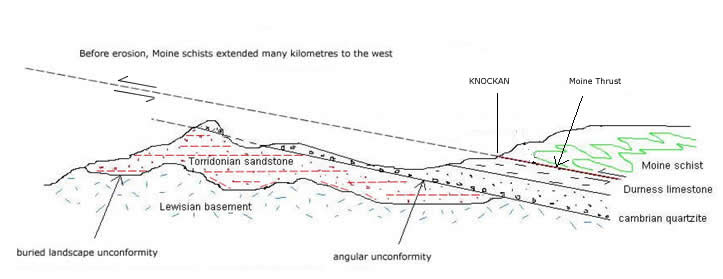
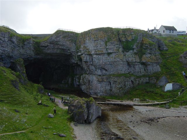
ASSYNT I was unable to be present on this Geowalks field trip, and this report on the geology of the North-West Highlands area has therefore been compiled from my own prior knowledge and a few photographs taken during a coach trip to the area in 2004. Summary: The main events in the geological history of the North-West Highlands may be summarised as follows: Intensely deformed and metamorphosed Lewisian Gneisses were formed during the period 3000Ma to about 1400Ma within the continent of Laurentia, which included large areas of Greenland and North America, as well as the basement of north-west Britain. These ancient rocks were very deeply eroded, creating a landscape of hills and valleys, and they were then buried by layer upon layer of water-lain red conglomerates and sandstones, the Torridonian Sandstones, during the period 1000Ma to 800Ma. Alluvial fans were often formed close to the Lewisian basement (see Skye and Raasay), but generally, Torridonian rocks were laid down horizontally and to a depth of up to 8 kilometers, so that the source must have been in very distant areas of the Laurentian continent. The junction between these two units is described as a buried landscape unconformity (figure 1). (At about the same time, thick sequences of sandstones and mudstones were being laid down much further to the east, in what is now the Northern Highlands area. These were to become the Moines, sometimes regarded as lateral equivalents of the Torridonian). A period of erosion followed, and the Torridonian formations became tilted to an angle of about 10 degrees to the north-west relative to their present configuration, before the top surface was eroded down to a horizontal plane. There then followed the first major marine transgression of the main geological record, beginning at, or a little before the start of Cambrian times, 545 Ma. Shallow seas spread over the margins of the Laurentian continent depositing sands (now the Basal Quartzites) and later limestones (the Durness Limestone) over the flat, planar surface below, so that the relationship with the older units is an angular unconformity. Usually deposition was on the Torridonian, but sometimes these sediments were completely cut out, to leave Cambrian rocks lying directly on Lewisian. Britain still lay far to the south of the Equator and was separated by a widening ocean, the Iapetus Ocean, from the continental fragment of Avalonia, which included what would later become England and Wales. Cambrian times saw an "explosion" of marine life. Rocks of this age contain the first clearly identifiable fossils, including the trilobites. Trilobites thrived also on the shores of the Avalonian continent, but the species found there are entirely different, because the Iapetus Ocean was too wide and deep for these animals to cross. Deposition of the Durness Limestone continued into early Ordovician times - until about 490Ma. But by now, the Iapetus Ocean was beginning to close, with oceanic crust being progressively subducted down into the mantle. Over the next 100 million years or so, a series of events took place which are known collectively as the Caledonian Orogeny. Volcanic arc fragments collided with Laurentia in an early phase known as the Grampian Orogeny. Later, the continent of Baltica smashed into Laurentia before Avalonia collided with the latter at an angle. When continents collide, sediments become compressed and folded, and high temperatures at depth cause these sediments, and other crustal rocks, to recrystallise as metamorphic rocks or to melt completely, forming granitic intrusions which are buoyant and force their way upwards to help build mountain ranges. And at the margins, against the hard, crystalline rocks of established continents, the sediments are forced upwards and over the margins of the continents as great overthrusts. In the case of the Moines, they had been victim to an earlier orogenic episode, during which they were metamorphosed at depth to become the Moine Schists, and then, in a late stage of the Caledonian Orogeny, perhaps around 430Ma, they were squeezed upwards and over the younger rocks of the Cambro-Ordovician succession as a series of thrusts, of which the greatest and most easterly is the Moine Thrust, the schists coming to rest many kilometers to the north-west. The soft young rocks of the Cambro-Ordovician provided a convenient glide plane for the westerly movement, so that it is no coincidence that the dip of the Moine Thrust often closely parallels the dip of the sediments below. Close to the Thrust, the intense shearing pressures against the rocks below stretched out minerals in the Moines to produce a rock called a mylonite. The apparent layering in these rocks fooled early geologists into thinking they were a continuation of the sedimentary succession below, but further up they are more obviously metamorphosed and how else can we explain metamorphosed rocks lying on top of an unaltered sedimentary succession other than by thrusting? In the Assynt district, that thrusting was accompanied by intrusive igneous activity which has had the effect of widening the Moine Thrust Zone in that area, to form what is known as the Assynt bulge or culmination. The heat of the intrusions has in places baked the Cambrian limestone to produce marble. By Devonian times, Avalonia was united with Laurentia along the Iapetus Suture, and Britain at depth was essentially as it is today. The story continues as a largely erosional one throughout much of Upper Palaeozoic and Mesozoic times. Britain crossed the Equator into the Northern Hemisphere during Carboniferous times. The next major event of which we see evidence occurred early in Tertiary times, around 60Ma. By then, the Atlantic Ocean had started to form, and North America was drifting away towards the west, taking with it much of the ancient continent of Laurentia, but leaving behind that tiny fragment which remains today in the far north-west, predominantly exposed to the west of the Moine Thrust. The continental break-up was accompanied by extensive volcanic activity and It was probably during this period that the whole area of the north-west became tilted towards the east to give the Cambro-Ordovician succession and the Moine Thrust plane the gentle dip of about 10 degrees to the south-east that we find today, and at the same time restoring the bedding of the Torridonian rocks - coincidentally - to the more or less horizontal state in which they had been laid down. Continuing erosion, culminating in the Quaternary glaciations of the last 2 million years, has sculpted the landscape as we see it today. Figure 1 illustrates how many of the isolated hills to the west of the Moine Thrust are built of horizontal layers of red Torridonian Sandstones, often capped by a layer of white quartzite, which had been formed by the fusing together of the grains of sand laid down in the Cambrian marine transgression. In many places, the Torridonian Sandstone has been completely stripped away to reveal once again the resistant rocks of the Lewisian, in a knock and lochan landscape very much as it would have been around 1200 million years ago! At Knockan Crag, it is possible to place one hand on the rocks of the Foreland, or Unmoved Zone, below and to the west, and the other hand on older metamorphic rocks which travelled many tens of kilometers from the east during the Caledonian Orogeny. The successions of the Foreland hugged the Lewisian basement below and were never buried by more than a few kilometers of overthrust rocks, so that they contain sedimentary rocks of as much as 1000 million years old almost completely unaltered by the passage of time! The Moine Thrust at Knockan Crag is line sharp and represents the end of a mountain range! ....Visit Knockan Crag - Discover the Planet! ............... (I will, some day!)
|
|||||||||||||||
|
|||||||||||||||
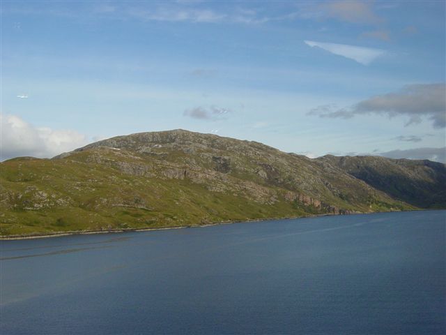
Fig.1. A geological cross section from north-west to south-east from the quartzite-capped summit of Cul Mor to the Cromalt Hills.
|
|||||||||||||||
|
|||||||||||||||